A Contour Survey shows the slope of your land and is generally done at the same time as soil testing.
The information collected from the Contour Survey is fundamental to determine the design of your new home, whether drop edge beams are required, the amount of cut and fill required and the location of service connections.
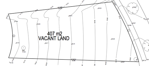
Below is an example of a Contour Surveyor:
If you are trying to interpret a Contour Survey, keep the following tips in mind:
Some builders will not undertake the Contour Survey until after the tender has been signed. This means that the tender will be subject to a Contour Surveyor and site investigation, and therefore allowances will be made for these items. So it’s a good idea to ask your builder to undertake a Contour Survey and soil test to firm up the price of your build before you sign a tender.
Generally speaking, the greater the slope of the land the greater the cost to build. However, if your land has a fairly steep slope it may be worthwhile considering a split-level design, which will reduce overall construction costs.
{{comments.Comment}}
{{replied.RepliedComment}}